Day 106: The Lookout

Day 106. Man, did I wake up rested this morning! Nothing feels better after a 30-mile day in the mountains than sleeping in late, in a bed. I must have known I’d want to give my feet a break today, as my pre-trip Hike Plan only called for 16 miles today. So I took a much appreciated Nero Day, and pushed my departure time from Killington to around noon. And with that extra time in bed this morning, I finished the latest (week 15) video. See above!

After breakfast (provided free with my stay at Mountain Meadows Lodge), I journeyed into the tiny adjacent town up the hill. There wasn’t much, but it had everything I needed. The outfitter is huge, and has great hiking and skiing supplies (fuel canister, check). Then, down the road is a market/deli for resupply with tons of hiker staples (deli sandwich for lunch, check). There’s also a post office, gift shop and visitor center with some neat things to check out. It’s a small skier/hiker town, but it’s a nice one.

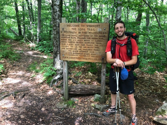
With everything acquired that I need to get to my next stop in 3 days (Hanover), I said goodbye to Killington and hoisted my once-again heavy pack for the steep climb out of town.

Side note, on my way to town, I ran into an old friend, Cinco, who I haven’t seen since Hot Springs. He stayed st a different motel, and was getting an earlier start to the day. It’s amazing how people can be within a dozen miles of you for weeks, and you don’t even know it. Like me, he’s been hiking quickly and solo for some time. He also planned to stop after 16 miles, so I said we’d catch up more at the shelter tonight, and said goodbye.

When I finally started, my hike was actually quite nice today. It didn’t rain more than a light drizzle, and the temperature was a low 60 degrees all day. There was a dampness in the air, that kept me just shy of dry while I hiked, but it felt cooling and nice against my normal shvitz. I’m much higher in enervation now, and can feel it in the colder air, so I’m going to get my winter gear back at the Whites as planned: Puffy jacket, long underwear, hat and gloves … nights are going to start to get chilly this high and this far north.

I passed a really nice waterfall (Thunder Falls), and then hiked along a handicap accessible boardwalk for a half mile. These were both great, but were early on in the day, and then it was back to he monotony of the muddy green tunnel. Unfortunately, the overcast sky did not provide any other good views or sights … until the end of my day.

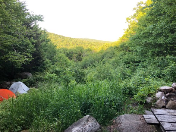
I had planned to go 16 miles to that shelter with Cinco, and honestly would have, if not for the amazing Lookout Cabin I stumbled upon after 14. This is a private and empty cabin that wasn’t really mentioned in the AWOL guidebook (or I would have surely planned on it). Built by the Lookout Farm down the hill, the owners allow hikers to sleep here if they are respectful of the property, and it is amazing. It stands at the top of a tall peak, looking out to the North and East for miles. The cabin is fully enclosed and in great shape (looks newly renovated), and even has a ladder to a lookout platform on the roof. All told, it’s a great place to spend the night! Especially, since the rain is supposed to get worse and pour hard overnight. I am even able to setup my hammock inside from the rafter beams.

So … sleep on a cold, dirty, wet, and exposed shelter floor? Or, hang in a clean, dry, warm, and enclosed cabin? After hiking past so many desirable cabins/shelters in the past, I wasn’t about to let this one go un-slept in. Easiest decision ever.

I’ll make up the 2 miles tomorrow easily, because I have a feeling I’m getting another great and restful sleep tonight.

Hello Neiman (Sharkbait)

  • Start Mile: 1705.8
  • Start Time: 12:00
  • End Mile: 1719.3
  • End Time: 17:30
  • Miles Hiked: 13.5
  • Miles to Go: 471.6
  • Lodging: The Lookout Cabin

Day 105: Killington, VT

Day 105. I woke up early this morning, eager to check the weather and evaluate options for the day. The latest update said it would rain starting around 11am, with chance for thunderstorms from 2pm through the night. Not the most encouraging news when you have Vermont’s 4,235 foot Killington Peak ahead of you … climbing the tallest mountain for miles is a brilliant idea in lightning, right?

But luck was on my side (at first), and the sky was clear and blue all morning. In fact, I thought maybe it would stay that way all day. No, I wasn’t that lucky. Around 1:15, just as I reached Governor Clement Shelter at Killington’s base, it started to rain. I hopped in the shelter to rest and listen to the sky. My cell service was out, so without radar updates, I needed to rely on my ears and what’s between them to evaluate the threat of danger ahead.

Side note, just before this break, I passed a sign signifying I was 500 miles from Katahdin. That was my happy moment for the day (photo above).

I gave it 30 minutes, watching, listening and contemplating. During that time, I didn’t hear any thunder, and saw 4 other hikers pass through en route to the summit. I decided staying any longer was silly and cowardly, and ventured upward after the others. The rain stopped as soon as I stepped out, and the next 5 miles to the top were pleasant. Easy peasy, right?

At the top, I got greedy.

I was now 20 miles into the day, and although an old and ugly shelter stood at the top of Killington Peak … I felt like I could make it the 10 miles further to town if I wanted. It was primarily downhill, so I estimated I could get there by 7pm … and truth be told, I still didn’t trust the possibility of thunderstorms up this high.

After 105 days, I should know better. It’s never just downhill. And it’s never simple when you want it to be. The first 7 miles were ok, but slow. The trail on this side of the peak had received more rain and was slick and dangerous to descent. At the bottom, things turned from bad to worse.

Now it was 6pm, and although I had only 4 miles left, I had to go back up another mountain and down the other side to get there. And, of course, it started raining again. This time hard … and now I heard the rolling thunder. As I stood at the Highway 4 road crossing, I contemplated whether to hitch to town from here, or go back in the woods. I didn’t want to have to come back here tomorrow, to earn those miles the right way, so I stubbornly and bitterly walked on. Oops.

Mother Nature decided this would be her moment to break me. She was going all in on this 4 mile stretch, and she had it in her to take me down.

Over the next 2 hours, the rain got heavier and heavier, immediately liquifying the muddy ground and layering an oily slick on the path of rocks. You see, the pristine Long Trail I was used to was now gone, as it split from the AT on this hill and took its nice groomed path northwesterly with it. I was back to huge rocks, uncleared fallen trees, and unnecessarily steep walkways.

And, as if this wasn’t enough, then the mosquitoes joined the fun. Somehow unscathed by the cold, wind and rain, these insects with a death-wish began their kamikaze attack on my calves, the only exposed limbs of flesh in the downpour. Bug spray was pointless, as it would wash off in seconds, so I settled into a rhythm of half-walking-half-crouching in order to slap/scrape the vile creatures off my legs with each step. I am convinced that this suicidal strain of skeeter was created in a lab somewhere here in Vermont, clearly having been enhanced with the DNA of rabid Mountain Lions.

Eventually, and unhappily, I made it to my destination. It was after 8pm and darkness had set in, but I finally reached the Mountain Meadows Lodge on the edge of town. This beautiful resort is on a lake, right on the trail, and happy to host hikers when not reserved for weddings or other weekend retreats. The owner met me, and served me some wonderful leftovers from last weekend’s wedding reception (which I devoured in seconds), then showed me to my room upstairs. This small venue has a couple dozen rooms above the attractions of the main floor, and I’m hoping to explore the place more tomorrow. For now, I’m too tired to move my feet another step, and will let myself fall asleep to the loud cracks of thunder outside and the gentle whimper of my crying inside.

Hello Neiman (Sharkbait)

  • Start Mile: 1676.4
  • Start Time: 07:15
  • End Mile: 1705.8
  • End Time: 20:10
  • Miles Hiked: 29.4
  • Miles to Go: 485.1
  • Lodging: Mountain Meadows Lodge

Day 104: Greenwall Shelter

Day 104. I have decided that Vermont, and it’s overlap with the Long Trail, is one of my favorite parts of the AT. Sure, it has its rocks, roots, and steep climbs, but it is a relatively nice path with some breathtaking views and a plethora of shelters/campsites. Yes, a plethora. I literally passed 6 shelters and 2 other official campgrounds during today’s hike! I finally stopped at the 7th shelter, but they are at most 5 miles apart, so I almost went further!

And the sights today, oh wow. I tried to capture what I could in photo/video, but an iPhone could never do it justice. My day was simply full of natural wonder and beauty. Today’s breathtaking moments consisted of standing at the top of Bromly Mountain Ski Resort, ridge walking Baker Peak, walking along the edge of Little Rock Pond (above), following the edge of Big Branch River, and even walking through a Rock Cairn Garden … which is an area of uniquely colored white rocks, stacked by dayhikers into a big collection of artistic towers (below).

And it’s a good thing I had such a nice hike, because rain is coming for the next 2 days. My attitude will be slightly less chipper, but I’ll also be to Killington the day after tomorrow, so any discomfort could be remedied pretty quickly with beer and burger.

I saw a lot of hikers today. A couple familiar AT thruhikers (Mumbles and Zoom-Zoom), though everyone else was mostly Long Trail thru or section hiking. Also a lot of day-hikers, as many of today’s stops are popular short hikes for locals. At Killington (30 miles away), the Long Trail splits off to the Northwest while the Appalachian Trail continues Northeast to New Hampshire. Although my path leads me into tougher terrains, I am definitely coming back to finish the rest of Vermont’s Long Trail in the near future (add it to the super long and growing list…).

Side note, I heard a couple updates on past friends ending their hikes this week. First, my friend Spice, who hiked in Shenandoah with me, was forced off trail in New Jersey from injury. Unfortunately, she fell and broke her leg and is back in the Midwest. I was very sad to hear this and wished her a quick and healthy recovery.

Second, my old tramily member, Leap Frog, is also back home. Her story is not a sad one, as she achieved what she wanted on this trail and decided to end her walk in Northern Pennsylvania. She’s happy with what she got out of it and so I am happy for her. Maybe someday she’ll decide to come back and finish … though, if she does, I’d recommend jumping up to Delaware Water Gap and skipping the rest of the rocks!!

In better news … tomorrow has a possibility for hot food! I’ll climb Killington Peak, Vermont’s 2nd biggest mountain (and 1st largest ski resort), sometime during the rainy day tomorrow. A snack bar is supposedly open at the top for hikers, though there’s a strong chance it is not yet open for the season (the guide says “mid-June”). Let’s all think happy summer thoughts together and maybe I’ll get lucky.

Hello Neiman (Sharkbait)

  • Start Mile: 1651.8
  • Start Time: 08:30
  • End Mile: 1676.4
  • End Time: 18:20
  • Miles Hiked: 24.6
  • Miles to Go: 514.5
  • Lodging: Greenwall Shelter

Day 103: Manchester Center, VT

Day 103. Well, as usual, I gave in to the temptation of food. I blame my shelter-mates last night though, as they had a long discussion about what meals they miss the most out here … burgers, pizza, mozzarella sticks … well damn, those all sound great. So, I was convinced on this town stop before I fell asleep. And it’s not so bad, a very nice town to visit (as usual in NE), and an easy 25 mile hike to reach it. And, this means I have a WiFi connection and can finally post last week’s video. See above!

The only difficult part of the day was at the beginning, as I climbed Stratton Mountain’s nearly 4,000 foot peak. This is the tallest mountain in Vermont, and although it didn’t feel too bad, it was tiring at this high altitude. I haven’t been this high up in months! At the top is a fire tower and a very small cabin, where 2 caretakers live and support the trail/hikers. They rotate out every few weeks (like I’ve seen with other caretakers), and were very willing to share history and information about this part of the AT/Long Trail. It almost seemed like their job was simply to inform hikers on trail history, and nothing more. It isn’t, but that was definitely the focus of our chat.

They were a very kind elderly couple, and they shared cookies with me in exchange for showing them how to use the facility’s cell phone and radio. I couldn’t believe that they had been here for 3 weeks already and didn’t know how to turn either on! But now they do, and we all feel much better for them being in the know. We also discussed yesterday’s med-evac, as that was obviously big news for the area. I filled them in on the details and then (after a couple more cookies), said my goodbyes and hiked down the mountain. The rest of the day was smooth sailing. Easy hiking on very nice terrain and mostly downhill. I passed 3 nice shelters before 5pm (all of which were empty … where is everyone??) and made it to the road crossing for town just before 6pm.

I made arrangements to stay at a “hostel” earlier in the day, which is really just the home of a kind women (Jen) who rents out her kids’ empty bedrooms in the summer. But with how expensive hotels are up here, spending $35 to stay in a house was a great deal. Unfortunately though, first I had to get to town, which was 5+ miles from the trailhead. Jen told me to hitch a ride from the locals, so … I stuck out my thumb.

I told myself I wasn’t going to hitchhike on this journey, it feels uncomfortable and awkward to me. And standing there, I felt very dirty and vulnerable. But, Jen assured me that this was a very hiker-friendly town, and that I’d be picked up quickly. She was right. Within minutes, a nice family stopped and offered me a lift to town. It turns out their father and youngest daughter are thruhiking the trail southbound right now, so they were happy to help. I thanked them and said I’d look for the dad/sister in the weeks to come.

Then I had my long-awaited dinner. Chicken wings, beer, burger and fries … all were inhaled in minutes to a feeling of guttural satisfaction. Jen picked me up at the restaurant after I finished and brought me to her home. After taking a shower, I crawled into bed and evaluated the next few days. I have enough food now (thanks to this side trip) to get to Killington, VT in 3 days. But, now I think I will stop there in the morning to resupply, and then head out again in the afternoon (like I did in Dalton). Two expensive stops in 3 days is probably not in the budget this week, plus I still need to make up 15 more miles before the 21st to get back on schedule before going off trail again for the wedding. Easy peasy!

Hello Neiman (Sharkbait)

  • Start Mile: 1626.1
  • Start Time: 07:00
  • End Mile: 1651.8
  • End Time: 17:55
  • Miles Hiked: 25.7
  • Miles to Go: 539.1
  • Lodging: Jen’s Place (Manchester Center, VT)

Day 102: Kid Gore Shelter

Day 102. Well, that was an interesting evening. The picture above is not of me, but it is a story worth telling in today’s post. Nothing as interesting as this medical evacuation happened to me today, but I’ll briefly rush through my hike so I can get to that story for you.

I had thoughts of doing the 18 miles planned today, or perhaps 23 if my feet were up to it. Coming down Harmon Hill this morning was a steep decent, but I met a nice family on their first backpacking trip in 30 years. They haven’t been out since the kids were born, and decided this was the year. The parents, Bev and Mike, were joined by their son for a section of the AT, and severely overpacked on food. To my advantage. When I passed them on the trail, they were eager to learn about my travels and to share their trail mix and apples in exchange for stories. Apples! Fresh produce was a welcomed treat and I thanked them for the juicy treats as we walked down together.

Then I climbed up, up and up. One hill after another for the next 15 miles. There weren’t many views, and the bugs kept me from stopping anywhere long enough to enjoy a rest anyway. So I rushed through the terrain and made my way to Kid Gore Shelter, unsure of whether I’d stay (18 miles) or go on to the next one (23 miles).

But when I got here, I knew I wasn’t leaving for 2 reasons: one good, one bad. The good reason is that this shelter looks out over a valley to the east, with a beautiful view at night and (supposedly) and even better view at sunrise. Getting to see that sunrise tomorrow is my primary motivation to stay here, I hope it’s as good as the guide books say. Here’s the view at night as I write this:

The bad reason, was because a hiker was waiting to get extricated by rescue services. He was a young hiker, on his 3rd day thruhiking the Long Trail (which overlaps the AT in Vermont). While hiking yesterday, he had a nasty fall and thought he tore a ligament in his knee. After a day of rest, he tried to hike out today but couldn’t get more than a couple miles before the pain was too much. So he called the local police and asked what to do, they said to wait at the shelter and they’d come get him.

Side note, Happy has a similar medical evac story from Montana that I knew of, but this was the first time hearing about/seeing it in person out here on the AT.

Now, let me say, I am incredibly thankful for the people that do this, and knowing they will come if needed is extremely reassuring. But, I was even more amazed by the process of this rescue. Approximately 3 hours after his initial call, just as I was finishing dinner, we heard them coming. Nine men, one women, a dog, and a stretcher on one wheel all rolled into the shelter. They cane from a back road behind the privy, the opposite direction of the Appalachian Trail. It is approximately a 1 mile hike up a secret unmarked trail, which is used only for maintenance and rescue purposes (I learned almost every shelter has these). The Fire Chief told us that they all hiked up together, after an ATV ride up a private dirt path from the nearest accessible road. The EMTs with them (2) immediately began gathering his vitals and medical history, and the others (consisting of fire fighters) waited patiently while assessing the exit strategy. I learned that the reason for so many people, was to make sure teams of men could carry him down in shifts, if needed. That wasn’t needed (nor was the stretcher), as the hiker was going to hobble down alongside them on his feet, with some assistance. The rescue team did not mind, and they all left together after about 20 minutes.

I hope I never get hurt out here, but it feels very comforting to know now what happens if I do. And, that’s just for calling 911. If I push the emergency button on my PLB device, the army and a helicopter are on their way to get me even faster. Now feels like a good time to symbolically “knock on wood”…

Hello Neiman (Sharkbait)

  • Start Mile: 1607.4
  • Start Time: 08:45
  • End Mile: 1626.1
  • End Time: 17:05
  • Miles Hiked: 18.7
  • Miles to Go: 564.8
  • Lodging: Kid Gore Shelter

Day 101: Congdon Shelter

Day 101. After yesterday’s antics partially up Mt Greylock, getting up the rest of it today was a breeze. I broke camp at 7:30 and casually made my way up to the top before 9am. Along the way, I passed a tiny pond with an old abandoned cabin on it. I’m not sure what purpose this tiny cabin on a tiny pond could have once served (old ranger station perhaps?), but it was a beautiful scene. Untouched by wind, the pond projected a perfect mirror image of the landscape into the water’s reflection. It was a really nice morning treat to see, I even stood for a minute with mosquitos biting to take it in. Here’s a photo below that captures it pretty well.

From there, it was maybe a half mile more to the top. And at the top was quite the setup. Since there is road access and a parking lot, this is a very popular tourist site, and there is a lot to see and do. At the top of the mountain, looking like a giant white lighthouse in the sky, is a veteran’s memorial tower. You can climb 100 stairs the top and see hundreds of miles in every direction. On today’s clear blue sky day, it was perfect, and felt like a makeup for my crappy view atop Clingman’s Done 3 months ago.

There is also a lodge and cafe, where you can spend the night for $40 or get a hot meal/drinks. I’m not sure what the accommodations are like, but that’s a great rate for a full-service lodge on top of the world. I should have kept climbing last night and stayed there! Instead, I awarded myself with a consolation prize of raspberry pancakes and coffee, deciding that a trip back was definitely needed.

Side note, all these “trip back” destinations are starting to add up. At this point, I should just plan to hike this whole damn thing again!

The rest of the morning consisted of climbing down the other side of Mt Greylock with dozens of day-hikers … it’s the weekend in June, I should have expected it. Everyone was very nice, though it was crowded. At the bottom, I crossed through the town of North Adams and had lunch at a park with a picnic table. I walked through a nice neighborhood to get there and watched a little league game taking place while I ate. Then I journeyed on, back up the next set of mountains.

But these weren’t just any mountains, no they were the Green Mountains … and within a couple miles I crossed into my 12th state. Vermont! Man, New England states go fast on this trail. I celebrated the achievement with a snack and a photo (above), then journeyed on again. Still having 14 miles to go to tonight’s shelter, I thought I’d make it to camp early enough, but I forgot about Vermont’s nickname.

Ver-mud.

Almost immediately, the trail (which now overlaps with Vermont’s Long Trail) became a mess of rock and mud, and I regretted leaving the niceties of Massachusetts so quickly. My pace was slowed significantly by muddy walkways, even though it hadn’t rained here in days. The problem, I think, is the many ponds and bogs that appear to leak water down the trail from up high. Massachusetts had these too, but somehow it wasn’t as bad. It’s nothing too compromising, just slows you down a bit. On the bright side, though, I did see a beaver swimming in one of the ponds, which was a nice addition to my animal sightings collection. Even got him on video before he slapped the water with his tail and dove down. That was cool to see.

I reached the Congdon Shelter before 7pm, and found a group of women here for a friendly overnight. No other thruhikers in sight, but a section hiker was setup at a campsite (the girls occupied the small shelter). The overnighters had a fire going, a bag of wine, tons of extra food, and a willingness to share … so we had a nice dinner together and enjoyed the campfire until the sun set. I am exhausted from today’s long trek though, so I called it a night early and hopped in bed.

Tomorrow looks to be a shorter day of only 18 miles, though if I can do more I may consider it. I’m nervous I don’t have enough food and stove fuel, so I may try to get to Killington in 5 days instead of 6. We’ll see. I could also hitch to one of the many towns within a few miles of the trail. I’ll see how tomorrow goes, but it’s good to know my options.

Hello Neiman (Sharkbait)

  • Start Mile: 1583.7
  • Start Time: 07:30
  • End Mile: 1607.4
  • End Time: 18:45
  • Miles Hiked: 23.7
  • Miles to Go: 583.5
  • Lodging: Congden Shelter

Day 100: Mark Noepel Shelter

(video fixed)

Day 100. VICTORY IS MINE! I AM THE STRONGEST MAN ALIVE! WILL POWER IS MAN POWER! ADRENALINE!! AAAHHH!!

… I’m sorry … I’m still pumped full of the caffeine, chocolate, and sugar that fueled this last epic climb … breath, Sharkbait, breath … ok … ok, I think I’ve got my heart rate under control … let me start over …

Today started out like any other day. I woke up, I packed up my hammock, and I hit the trail. I ate a meager breakfast of my 3 remaining bites of trail mix and climbed down the 3 quick miles to Dalton, MA. I was hoping to get in town around 8am, and back out before noon. The entry time was close, as I walked down Main Street at 8:30, and into the Dalton Community Rec Center. For a $3 “donation”, they’ll allow hikers to shower here, to which I indulged greedily. I needed a shower bad from all the bug spray and humidity the past week, so let’s just say I took my time … and it was liberating.

Finally feeling clean, I grabbed breakfast at the Dalton Restaurant across the street, a diner attached to a very delicious bakery. I downed a plate of hash, potatoes, eggs, and toast and then washed it down with a homemade jelly donut. Yum! Next on my town to-do list was laundry. I’ll save you the dramatic story, but I walked a mile away to the laundromat, only to find out it was closed, then walked back to Main Street to the Shamrock Inn who said they would do it for me for $5. D’oh! That was a very frustrating hour wasted.

While waiting for my laundry, I picked up my resupply box and organized it for the next long section of hiking (6-7 days). I only sent 4 days of food, so picked up a few additional items at the gas station and made note of what else I need from the Dollar General in Cheshire. Then I had lunch at a sub shop with Bones, Pritch, and Reboot who strolled in around 11.

Reboot was staying in town, but the other 2 planned to hike on like me (as we discussed a couple nights ago). They headed off and I went back for my laundry. Long story short, the machines were backed up and I didn’t get out of town until 2:30. Yikes, 14 more miles to go and already so late, not what I was hoping for. The people at the Shamrock Inn are incredibly kind though, so I enjoyed the time spent hanging out in their Guest Lounge (a living room thing next to the office with the laundry machines, a TV set and an old computer). They asked me to send a postcard when I finish, so they can add it to their wall, and I promised I would.

Side note, this is a common activity among thruhikers. Once complete, you make postcards of your celebratory pose on Katahdin and send thank you notes to all the people along the way that helped you get there. I love the idea, and will likely do the same.

The hike to Cheshire was a nice 9 mile stroll up and then back down one huge mountain. It had some steep moments, but overall a very soft and doable pine needle covered path. The first business you see in town is an ice cream and sandwich shop. They had my new favorite, Hershey’s Raspberry, so I ordered a double scoop. Yum again! Then I walked the trail around town to Dollar General. I picked up the few remaining items (tortillas) and a few treats (gummy bears), then went outside to assess my options. It was 6:00pm, and I could either a) setup my tarp-tent behind a local hiker-friendly church and sleep in Cheshire, or b) try to get to the next shelter before dark. The next shelter was 4.4 miles away, 2/3 of the way and 1700 feet straight up Mt Greylock (the tallest peak in Mass), and there was just over 2 hours of sunlight left in the day.

CHALLENGE ACCEPTED!

I ran back in the Dollar General and purchased a power dinner of Mountain Dew, Grandma’s Peanut Butter Cookies, and a king size Snickers … then I ate devoured the caffeine and sugar in 2 minutes and walked into the woods.

I’m not sure any written testimony could possibly sum up what happened next, which I must have realized … because I documented the whole thing on video as I went (above). Fueled only by sugar and stubbornness, I climbed up that mountain fast, even though I was carrying at least 5 more pounds of food than normal. More accurately, I ran up that mountain. At an insane 3 mph speed, I charged straight up Mt Greylock in 90 minutes, in what I am now calling the “Climb of Insanity”. Enjoy the movie.

I may be getting a little nutty on the last lap of this hike, but damnit if it isn’t fun out here. The overload of caffeine to my system may have had something to do with it too…

Hello Neiman (Sharkbait)

  • Start Mile: 1566.8
  • Start Time: 07:10
  • End Mile: 1583.7
  • End Time: 18:50
  • Miles Hiked: 16.9
  • Miles to Go: 607.2
  • Lodging: Mark Noepel Shelter

Day 99: Kay Wood Shelter

Day 99. Man, today was another beast of a day. Besides the bugs (which were bad again), it was simply long. I’m sure I’ve already come to this realization many times before (and likely in writing), but I think 25 is the max miles I should do per day. I can do more, but it’s always a bit more painful than necessary, and my feet start tripping up by the end dangerously. Today was a longer day than I should have done, but in the end I’m glad I did it as it will make tomorrow fantastic.

I’m camping at Kay Wood Shelter, just 3 miles shy of Dalton. Tomorrow morning, I’ll hike in for breakfast, a shower, laundry, and resupply. Then I’ll be done in time to hike to Cheshire for lunch, and then to the shelter after that for dinner. I can get two nice town stops (the AT literally walks down Main Street of both), and still put in 18 miles. The past two days were tough, but tomorrow should make up for it, and without wasting too much time and money for the reward.

I’m also basically out of food, so I didn’t have a lot of choice in the matter. Oops.

One sad outcome though. In setting this up, I was forced to skip a shelter stop I was really looking forward to. The Upper Goose Pond Cabin was only 10 miles into today’s hike, so too early to stop for. And it was a 0.5 mile blue blaze side trail that I reluctantly decided not to take, knowing how many miles still lay ahead before the day was done. This shelter is supposed to be one of the best places to stay on the trail. It is a large red cabin maintained and staffed by the AMC and NPS. It has 14 bunks, and houses s caretaker on hand during the summer. As it rests on a large pond, there is swimming, canoeing, and a beach for fun times. And, best of all, the caretaker makes a pancake breakfast in the morning. All this is to say, I’m very sad I skipped it. I can’t do everything on this trail and finish under 5 months though. And for every missed Cabin there is a found treasure of another sort. Luckily, today I had two of them that were great consolation prizes.

First, very early in the day, was a “Trail Stand” on the side of a farm. This unmanned shed provided cold sodas, candy bars, and fresh eggs for sale, and a power chord to charge electronics. I enjoyed a morning Mountain Dew and Cliff Bar for 2nd breakfast, then headed up Baldy Mountain.

Eight hours later, towards the end of my day, I stopped at another farm. This one was home to the famous “Cookie Lady”, a well-known Trail Angel that provides free cookies to hikers, as well as water and trash bins. She and her husband live on a blueberry farm, and offer those for sale as well (when in season). They were very kind and the late-afternoon snack was greatly appreciated

At my shelter tonight are a few section hikers, but no one else. I plan to meet up with a few thruhikers in Dalton tomorrow though, so this mini bubble of familiar faces should continue a bit longer. e.g. Bones, Pritch, Mouse Trap, Hungry Cat, Transformer.

Hello Neiman (Sharkbait)

  • Start Mile: 1539.3
  • Start Time: 07:00
  • End Mile: 1566.8
  • End Time: 18:50
  • Miles Hiked: 27.5
  • Miles to Go: 624.1
  • Lodging: Kay Wood Shelter

Day 98: Shaker Campsite

Day 98. It’s about damn time. It only took me 14 weeks, but I finally saw my first bear on the AT. I had all but given up by now, accepting that my journey would be one without any sightings for the first time in trail history … but not anymore! I finally saw one, actually 3, as it was a mama with 2 cubs.

It was pretty much the best way to see a bear too. They were on the other side of the pond in my photo above (which I took a few minutes before, so not visible), and walking away from the trail. I had a good minute to watch in silence from the safety of my side while they walked the edge and then bounded up the hill. It was beautiful and perfect. I got a nice video but no good photo.

And it was a perfect day for a nice long hike, so I did just that. High 60s, partially cloudy, no wind/rain, and a mostly soft trail of pine needles to walk on. There were some steep climbs, per usual, but the views made it well worth it, and there was plenty of water everywhere. I think I passed a dozen gentle streams, 5 ponds, and even walked alongside the Hausatonic River for a mile. Everything was picturesque, peaceful and still.

Except one thing.

One damn thing.

One million of the damn thing.

Mosquitos.

All those ponds and streams were breeding grounds for tiny blood-sucking demons of Satan, carrying out his torturous will to suck my body dry. Arms, legs, hands, neck, ears, face … everything exposed was a feast for their feeding frenzy.

At first I tried to swat them all away, but by the time I reached a road 9 miles in to my day’s hike, I knew it was a battle I could never win. So I pulled out my Ben’s 99% DEET bug spray (the greatest product ever invented), and took a Flashdance-like shower in it right there on the side of the road. (What a feeling…)

Ok, no. Before anyone freaks out and starts lecturing me on the cancerous risks of bathing one’s body in a layer of DEET, I only sprayed a tiny bit. One quick spritz, spread about thinly, is all I needed and the creatures bothered me no more. Until a couple hours when it wore off. Damn it!!

So I sprayed again, and then conceded myself to swatting afterwards if needed. For the most part, I survived, though I did wear a buff over my neck, face and ears for much of the day. It was a long grueling day, from the buzzing and biting perspective, but not enough to dampen my spirits too much. I would say I won the battle, but the war is far from over. I’m hiking out tomorrow morning to greet my foe with head net on.

Most of the hikers at last night’s campground shared my plan to hike 22 miles to North Mt Wilcox Shelter tonight. But when I got there, it wasn’t even 5pm and I felt like going on. So I did another 4 miles downhill to a campsite at the bottom of the mountain. Bones and Pritch were there when I strolled in, whom I’ve leap-frogged with a bit the past few weeks. This campsite is nice, like last night, with a privy, bear box, and elevated tent platforms. It was built on the remnants of an old Shaker Village, so there was some neat history to read about while I ate dinner. I hung my hammock next to the only remaining structural wall of what used to be a barn, and thought about how strange a spot this was for 100 people to live and work here 200 years ago. It’s literally on the mountainside. I’ll have to read up on the Shakers more, they are an interesting part of history along this trail.

Speaking of history, I also passed the town of Great Barrington today, a place of some historical significance: the last battle of Shay’s Rebellion and the birthplace of W.E.B. Dubois were here. It would seem that is a town worth visiting some day, as both peaked my interest. I saw a nice monument commemorating the rebellion location, but did not venture in to town for anything else. I regret having such a strict schedule to keep, as I’d like to explore some of these towns more.

I’m only 30 miles from Dalton though, and if I’m up for it, I could do that all tomorrow. Maybe. We’ll see how I feel in the morning after today’s long day. Alternatively, I could do only 19 or 27 miles, and then hike in for breakfast the next morning. That sounds like a better plan, but we’ll see.

Hello Neiman (Sharkbait)

  • Start Mile: 1513.8
  • Start Time: 07:45
  • End Mile: 1539.3
  • End Time: 18:40
  • Miles Hiked: 25.5
  • Miles to Go: 651.6
  • Lodging: Shaker Campsite

Day 97: Glen Brook Shelter

Day 97. Hello Massachusetts! And just like that, I’ve reached my 11th state. I crossed the border (and the 1500 mile marker), and all that’s left now are those 3 grueling states in the corner of America. Those happen to be 3 of the hardest state terrains, but who cares, it’s all hard. From here, the end feels like it’s within reach, and that’s a great feeling to have. As for today’s post, I’m feeling a bit pensive and creative, so I’m going to break from my usual hiking summary and do a philosophical interview to recap my day and feelings instead. This may be silly, but who cares, it’s fun and different. And Different is Good.

Michael: I heard you met a 6th grade class on a field trip today and they asked how this experience has changed you. Has it?

Sharkbait: Hmm, well to be honest, not much. At least not in some big life-altering way that other people out here are searching for. It hasn’t provided the answers to all life’s questions … but then again, I didn’t come out here searching for that. However, it has taught me how to appreciate the simple things in life more, and focus on what makes me happy daily. I’m sure these two areas of growth will be more pivotal parts of my life in the future because of this experience. Oh, and worrying less. It’s so easy to be carefree on the trail and give ones usual stressful mind a break. There is so much to love in the day, and it’s not worth spending a second worrying about what could go wrong. If you do, you’ll miss what’s right in front of you. Like a waterfall, or a clear mountaintop view, or (most often in my case) a giant black snake.

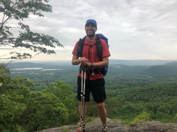
Michael: You’ve hiked with many different groups and partners, but you are still doing this by yourself. Do you feel alone out here, and do you like the solitude?

Sharkbait: You really are never alone out here, and I’ve yet to camp by myself once in 97 days. In fact, tonight is a big group with familiar faces at my campsite: Transformer, Hungry Cat, Mousetrap, and 6 others. I haven’t seen Mousetrap since Harpers Ferry, but it feels like we hiked together just yesterday. Even when you walk 16 miles “alone”, you are still passing people (or being passed) daily. Dayhikers love to stop and chat, townsfolk often do too, and let’s not forget the cars/trains … you hear them pretty much all day every day, reminding you that you are never truly out of civilization. I like hiking alone though, which is new to me, and there is definitely a sense of tranquility in that for me now that wasn’t there before. That kind of solitude is welcome.

Michael: We all know how much you hated PA, has the trail improved for you since?

Sharkbait: Oh yes! I rebooted my mental state at Delaware Water Gap with a few days off and I can honestly say I’m loving this trail again. I had a great time with my dad that just finished, and I’m back to being excited for each day’s hiking challenges. For example, today was a beast of a day! I climbed 4 huge peaks in cold/wet conditions, slipping and struggling most of the way. But I loved it. Lion’s Head provided amazing views of my last week’s journey, then Bear Mountain (highest peak in CT) showed me everything coming up in Massachusetts. It was the toughest climb I’ve done in weeks, but the views were well worth the trial. And they stayed with me another few miles as I ridge-walked to Mt Race and then up Mt Everett. I could see hundreds of miles across MA and my adrenaline was pumping with excitement to take this state on.

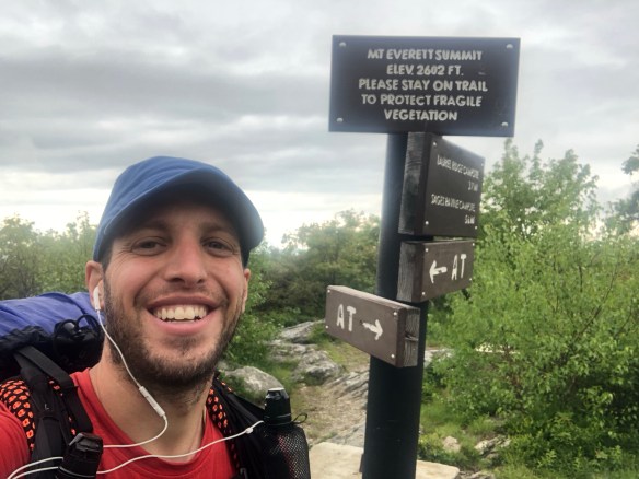
Michael: Sounds like you did a lot today, what was your favorite moment?

Sharkbait: Well, the plethora of views I just mentioned are probably it, they were simply spectacular. But I also had a great time at camp afterwards. I got in around 4, and contemplated going another 8 miles to Great Barrington, but decided to have a casual evening instead. I made a big dinner, I rinsed off the day’s dirt, and I called my wife. But the best moment may be just moments ago as I was typing this. I sent Huevos a quick note that I was almost to his hometown of Dalton, and he called for a quick video chat. We talked for a few minutes and I learned he is in Harpers Ferry, but still hiking strong. Huevos was a fun part of my tramily in Georgia, and I’ve always wonder how he’s held up since. I heard rumors of him at times, but nothing concrete. I’m happy to report he’s doing great, still hiking and now loving life! He told me that he finally found his own personal happinesses from being out on the trail, and it warmed my heart to hear it. Love that kid.

Michael: What about the worst?

Sharkbait: Do I have to have one? I’m not sure I do. Well, ok, how about this. I passed by Salisbury, CT without stopping in for breakfast. I knew Hungry Cat was planning to, and I could have joined him at one of the many delicious sounding bakery’s. Oh well, money is tight now and I have plenty of food in my bag, so no big loss. But I’ve been spoiled the past few days and oatmeal wasn’t exactly an exciting alternative.

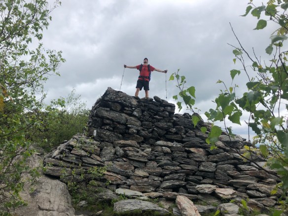
Michael: You have hiked 1500 miles, you must feel like an expert of the Appalachian Trail by now. What advice do you have for future thruhikers reading this?

Sharkbait: Enjoy every moment, because it is a gift to be able to do this. Life back home is waiting to crowd you and stress you again, so treasure everyday where food, water, and a dry campsite are your only real concerns. Don’t get surly (like everyone Happy met), and instead take time off when your spirits dip low. Stop at the views, take the side trails, talk with the people, and soak up every moment of the hike straight to your heart … because it will be over before you know it. I can’t believe I’m nearly 3/4 finished…

Also! Keep a daily blog. Writing each night will keep your mental state strong while also capturing your experience real-time to go back and relive again after. And if you get bored writing the same thing every day, you can mix it up with something goofy and different like this interview. You really were very smart to suggest this tonight, Michael.

Michael: Thank you, it’s a gift.

Sharkbait: And, if you aren’t too boring, faithful readers will come along and encourage you along the way. They are fantastic at motivating you to keep going on your worst days … and congratulating you for your accomplishments on the best ones. Thanks everyone!

Hello Neiman (Sharkbait)

  • Start Mile: 1497.3
  • Start Time: 07:55
  • End Mile: 1513.8
  • End Time: 16:10
  • Miles Hiked: 16.5
  • Miles to Go: 677.1
  • Lodging: Glen Brook Shelter