Day 77: Lickdale, PA (Swatara Gap)

Day 77. I broke one of my golden rules today, and all I can blame it on is the desire for a dry bed. In my pre-trip planning, I said I would never walk more than 1 mile off trail for resupply or lodging. But, when it rains all day … it is easy to convince myself otherwise. So I am sitting here at the Fairfield Inn of Lickdale, which is a 3 mile road walk from the AT, drying off and warming up.

This week of non-stop rain is going to seriously test my will, but as I mentioned yesterday, it is great to know I have options like this available if I want them. And today, I wanted them. (Spoiler alert, I’ll probably want them tomorrow and the next day too…). As for Lickdale, this town’s offering is basically just a truck stop off of highway 81, with a few fast food and hotel chains surrounding the off-ramp. But it just so happens, those are the two things I like most in this situation, so there is a smile on my face.

The whole day’s hike can be summed up as “rain and river”. The rain started overnight and didn’t stop all day (still hasn’t, and won’t for days). Because of this, the otherwise soft dirt trail was converted to a small river consistently along the way. I hiked a slow 2 – 2.5 miles an hour as I did my best to walk along the “riverbanks” or step on any rocks/roots protruding high enough up. I’m not sure if the photo above does it justice, but that is pretty much what I had to deal with non-stop. I eventually gave in and walked through it naturally, albeit reluctantly.

There were some neat sights today I would have enjoyed on a better day, but only stopped briefly to see before walking on: a waterfall, an old coal mining village, a steel bridge, and a couple vistas. All would have been nice rest breaks to take in, had the weather not dissuaded me. Still, they were great to see and provided momentary mood brighteners.

The trail was manageable for the first 10 or 13 miles, but then it started to drain on me and my mind wandered to how I could creatively solve it. I finished my planned 18 miles at 3pm, arriving at a small but dry Rausch Gap Shelter. Two of the hikers from last night were already set up there, but another hiker was contemplating going on.

His name is Hokie Pokie, and we quickly came up with the plan together to hike another 5 miles to the highway, and then 3 more off-trail to town. It would make this a long 27 mile day for me, but I didn’t care if it meant a comfortable rest afterward.

After the decision was made, we immediately set out. I knew Hokie Pokie from a couple sporadic meetings within the last couple weeks, and he seemed like a nice enough guy to share a room with. Those last 8 miles were anything but easy though, as our spirits was low and our energy lower. We hiked it in 3 hours and ended with a celebratory Burger King dinner before settling in at the hotel.

My conscience is also cleared slightly in that this helps solve my problem for tomorrow’s distance concern. By doing 5 more official AT miles than planned today, I can attempt to push for another 26 miler tomorrow and reach Eagles Nest Shelter. However, I also have the option of doing only 20 miles and staying at a hostel I didn’t notice earlier. I realize I’m becoming a bit of a rain wimp, but given the 5-day forecast … I think we all know what my decision will be tomorrow afternoon. And I’m perfectly ok with that.

Hello Neiman (Sharkbait)!

  • Start Mile: 1159.3
  • Start Time: 08:00
  • End Mile: 1183.4
  • End Time: 18:40
  • Miles Hiked: 24.1 (+3.0)
  • Miles to Go: 1007.5
  • Lodging: Fairfield Inn (Lickdale, PA)

Day 76: Peters Mountain Shelter

Day 76. After a surprisingly good night’s sleep at the Doyle, I woke up refreshed today and ready for a Nero Day. I wanted to have a hot breakfast and then do some laundry, but the only other goal was to reach Peters Mountain Shelter 11 miles away before today’s storm hit. Since today’s hike was primarily ridge walking, being exposed on the highest elevation in the area would be dangerous and stupid.

I left the Doyle around 7am and headed across the street to Goodie’s Restaurant. A small town breakfast joint with the basics. Nice people and good food were plenty, and I soon had my fill (for $8). Next, I headed down the street to the laundromat. I ran into a couple new faces there, Domatello and Joe Kool, who did a crazy 45 mile hike into town over night. They were waiting for the Doyle to open and killing time where they wouldn’t bother others. I could not believe their long day and told them a day of rest was well deserved.

Doing laundry took about an hour, and I killed time reading magazines and planning out the day. I looked goofy wearing just my rain gear while everything else washed and dried, but that’s pretty common on the trail. I call this the Backpacker Tuxedo, as it’s about as classy as one can get. I couldn’t resist a photo to capture my silly moment (above).

With everything clean, I packed up and headed out of town. The next 2 miles is spent walking through Duncannon residential neighborhoods and crossing the two giant rivers that meet here (the Susquehanna and the Juniata). Although both rivers were brown and mucky, it was still a beautiful sight to take in.

Then the climb went up. Getting back in the mountains meant a climb up 1000 feet over the next couple miles. Following that, it was ridge walking along a mix of soft trails and rocky precipices. All in all, not too bad a hike, though I was very sluggish from the morning breakfast I ate far too much of. I also was caring extra water (3.5 liters total), as the guidebook warmed of no stream access throughout today’s entire journey. It was a blistering hot day, so the extra water was heavy, albeit necessary.

I reached my shelter destination very early in the day, around 3pm, which was perfectly timed. Within an hour the sunny blue skies turned to grey and thunder was heard menacingly in the not too distant distance. By 4pm, it hit … hard. Rain, wind, hail, lightning and thunder barreled across the mountain range in menacing force. This shelter is very well built though, as if for just this storm protection purpose. It has a lofted sleeping area away from the exposed side, and has a giant tarp to roll down as a wind/rain block for most of the exposed area below. The picnic table is in the shelter as well, which sleeps 12 comfortably. You could tell it was fairly recently built, so I was happy to be in its safety to wait out the carnage.

I ate an early dinner and crawled into bed until the storm passed. After an hour or so, you’d barely know it rained at all. Some other hikers cane and went, and now 5 of us remain for the night. I believe Scutch and Apollo were planning to make it here today as well, but the storm may have deterred them earlier. It’s still early as a type this (6pm), so they or others may wander in before the night is through.

This section of the AT has very spread out shelters, which makes planning both easy and difficult. From here, it is 18 miles to the next one, then 13 more, then 20 after that. So tomorrow’s destination is no problem, but then it gets tricky. I’d like to do somewhere between 13 and 33 the day after tomorrow, which means I’ll be camping at whatever tentsite I can find along the way. But it’s also supposed to rain all week, meaning I’ll be camped out in the wet. Not my ideal situation, but I’ll make do. Port Clinton is the next town stop, 60 miles from here. So I’ll likely come in cold and wet, but that warm bed is always good motivation to push through the rain.

When people ask me why I chose to hike the AT instead of the PCT (closer to our home in Los Angeles), this is the reason I tell them. The community and support along this trail is a great aide to completing it. Knowing I can get to a town or hostel every few days is a huge help, and can get you through the toughest of dilemmas. More than once, I’ve been at low spirits from weather and been able to find a bed or ride to a bed within hours. That can go a very long way in helping heal the mind and spirit while traversing the wilderness for 5 months. So because of that, I’m not too worried about the rain to come. It will be miserable during (especially on the ridge rocks), but it will end quickly and provide me a place to reboot and keep moving North.

Hello Neiman (Sharkbait)!

  • Start Mile: 1148.3
  • Start Time: 09:45
  • End Mile: 1159.3
  • End Time: 15:00
  • Miles Hiked: 11.0
  • Miles to Go: 1031.6
  • Lodging: Peters Mountain Shelter

Day 75: Duncannon, PA

Day 75. I got a late start out of Boiling Springs today, expecting to do a short 14 mile stroll to Darlington Shelter before today’s forecasted rain arrives. Spoiler alert for the week, it’s supposed to rain and storm nonstop, so this will probably be a common thought each morning. However, after just a few miles, I ran into old friends Scutch and Apollo, who were planning to go 15 more after that into the town of Duncannon.

I didn’t really want to do 25 miles, but they made it sound like a challenge. And a challenge, whether intentional or not, is pretty much all my competitive spirit needed to decide I could do that too. In looking at my weather app, the forecast had also shifted to clear skies until later at night … and that was all it took.

It also helped that today was another mostly flat one, as the trail wound through more pastures and farmlands. One landmark early on was called Scott’s Farm, which is actually an ATC regional office. There wasn’t much to it, besides a couple picnic benches and water spigots, but it was a friendly place to rest. The farmhouse was off limits and the water contaminated, but it was a good snack stop regardless.

I reached Darlington Shelter around 2pm and realized I could easily get to town by 7pm at my current speed. I had lunch their with a couple flip-floppers (who thought I was a bit crazy to go on), then headed north again. Noodle, one of the flip-flop hikers told me to keep a lookout for Field Trip, a friend of hers I’d soon pass ahead.

About an hour later I found him, crouching a couple feet off trail. Thinking I may have stumbled upon an emergency #2 in progress, I announced my presence and approached slowly. Thankfully, my assessment of the situation was wrong and he was instead admiring something on the ground. When I got near, he excitedly pointed out a very rare and beautiful wild flower hidden in the grass. I immediately recognized it as the official flower to my home state of Minnesota – The Pink Lady’s Slipper! I have not seen one in bloom since I was a young child, so shared in his excitement and took a few photos for myself. A beautiful find to see this rare orchid along the trail!

Later on, I had another neat sighting, as a trail crossing was marked with orange blazes for the Darlington Trail. This is probably only interesting to me, but “Orange Blaze” was stupidly the name I wanted to give myself in my pre-trip planning. I know, it’s dumb. I soon tossed that idea out and let the trail name me in it’s own way (Hello Sharkbait!). But it was neat to see the idea represented in real life.

The last 5 miles were pretty rough terrain, as my favorite rocks were back again to mock and torment me. It started to drizzle as well, which didn’t help the spirits much either. But I was hiking alongside Scutch and Apollo now, so the time passed quickly as we chatted in stride. They are a newly engaged couple from Ohio, hiking the trail together before relocating to their hometown for work. Really nice people and very strong hikers. They average 25+ miles a day! I’m actually surprised to see them, as it had been a long time since we met back in North Carolina. Apparently a bad case of food poisoning pushed them off trail for a few days, which is how I was able to catch up. Ironically, my sister and her family saw them twice over the past couple weeks, though I kept just missing them.

Around 7:15, I made it down the last mountain and into Duncannon. I somehow missed a turn about 1 mile back though, and ended up on a side trail down from Hawk Rock. It emptied in the same place, but means I missed that official mile of the AT. If I were a purist, I would have turned around and climbed back up to the junction … but I’m not a purist and consider that mile done with an asterisk.

Walking into town, I straddled the road for another couple miles until I reached the famous and historic Doyle Hotel (pictured above). I’m not sure I can justly describe this place accurately, but I’ll try. The Doyle is an institution on the AT. It is an old 3-story hotel originally built in the 1770s, and hasn’t been upgraded much since. It burned down in the early 1800s, was rebuilt and bought (then sold) by Budweiser at the turn of the 20th century, and has hosted hundreds of hikers since Jack Doyle bought it with his Irish Lottery winnings in 1944. The current owners acquired it in 2001 and are old but sweet, caring greatly for this building and the hiker community that now supports it. The bar has good food and drink as well, and the atmosphere is very friendly.

The accommodations are another story though. I enjoyed it, but anyone with TripAdvisor standards above 2-stars should pass this place up. My room has just enough space for a bed and dresser, both which could be original 18th century furniture. The carpet is at least 40 years old, and the mattress and linens could easily be as well. A bucket exists in the corner, which I assume is to collect water from the ceiling if it rains. The hotel has one communal bathroom/shower on each floor, which was riddled with water damage. As I took a shower, water dripped down on me from the shower being used above through a hole in the ceiling.

I say all this not to scare you away or defame the place, but to set the expectations of hikers who make it to Duncannon in the future. Like I said, this place is an institution and worthy of everyone’s visit. I actually like it quite a bit and plan to Nero here tomorrow while I do laundry down the street. I don’t think I could stay another night though, everyone has their limits…

Hello Neiman (Sharkbait)!

  • Start Mile: 1122.7
  • Start Time: 09:15
  • End Mile: 1148.3
  • End Time: 19:15
  • Miles Hiked: 25.6
  • Miles to Go: 1042.6
  • Lodging: The Doyle Hotel

Day 74: Boiling Springs (PA Road 174)

Day 74. Week 10 video is up. Tons of family in this one as I close out SNP and reach Harpers Ferry. Enjoy!

Bad weather loomed above me today, but I was able to stay dry most of the morning. Eventually I was overcome by late afternoon and the rain opened up over me, but even then it wasn’t so bad. It’s definitely easier when you know you are hiking to a fine bed at the lovely Allenberry Resort again.

After last night’s late night escapades (hockey playoffs, beers, and jigsaw puzzles), it was slow moving for all of us in the morning. Eventually we made our way to breakfast at Cafe 101, which has a big backpacker breakfast of eggs, toast, potatoes, meat and pancakes for something like $9. I of course ordered it, though couldn’t come close to finishing … I think a half gallon raspberry ice cream is still taking up most of the real estate in my stomach.

following breakfast, I made a quick stop at the outfitter for a new food bag, then we went back to Allenberry to pack up and hit the trail. One of the backpacks I ordered came in on Thursday as well, so my sister brought it up and I transferred the contents of my old pack to the new ULA OHM 2.0 to test it out. It was perfect. The size was perfect, the fit was perfect, and the comfort was good. I say only good for that last one because after a full day of use, I can tell I need another day or so to “break it in”.

With my shiny, new, waterproof backpack, I was in great spirits and ready for some rain hiking. The family joined me for the first couple miles, but then we said goodbye and I continued on northward. This was the last weekend with them, though they will be joining up again for part of the White Mountains.

Besides it being a much longer day that I first thought, there were only two memorable moments in today’s hike to share:

1) The Rock Maze. A 1 mile stretch of trail that meandered over, under and around giant boulder crevices and throughways. It was a bit frustrating to get over one obstacle, only to have to scour your surroundings for the next directional maze clue. But it was also really fun, as you can get creative exploring and figuring out which way to turn next. A good activity for a normal day, albeit not as much so in the rain.

2) The pastures. The final 2 miles into Boiling Springs cross through big farm fields. The trail was purposely setup to cross through here in order to maintain the historical accuracy of the trail’s footpath trough farms of this area in the past. It was wet and smelly, but otherwise calm and relaxing.

The rest of the hiking today was the usual … mostly just uphill and downhill. But it was dry-ish until close to 5pm. It was drizzling all day, but at 5pm the storm finally hit me and it rained hard the rest of the night. Since today’s hike had me hiking late into the night, that proved to be a pretty long time. Three cold hours.

But eventually I got to PA Road 174 and walked back up the hill to the resort. I am exhausted as I type this, so I’m headed to bed. Tomorrow brings more storms unfortunately. Happy trails!

Hello Neiman (Sharkbait)!

  • Start Mile: 1103.4
  • Start Time: 12:30
  • End Mile: 1122.7
  • End Time: 20:15
  • Miles Hiked: 19.3
  • Miles to Go: 1068.2
  • Lodging: Allenberry Resort

Day 73: Pine Grove Furnace

Day 73. Another beautiful day in the books! And a pretty important milestone and achievement to boot. I will admit though, it was really hard to leave Quarry Gap Shelter this morning … it was so picturesque and tranquil at sunrise, I simply had to take it in as long as possible. But as 8am approached, I reluctantly packed my bag and headed north like I’ve done for the past 10.5 weeks.

Today was an important day as I had miles to put behind me and the official halfway point was waiting to greet me at the end of my hike. Since I had that good long day yesterday, it was only 18 miles today. The day went really quick and by 1pm, I reached a monument on the trail displaying the officially halfway point (though technically, it does move a bit each year so probably was off by a mile or so). Regardless of technical accuracy, given it’s clear significance, I snapped many photos to commemorate the moment. Then I sauntered on to finish the last 3 miles of my day.

However, I was fortunate to yet again have my family come out and join me, and soon heard the tramping of tiny boys’ boots on the trail ahead of me. I gave a patented Tom Neiman “Yo”, to test the audience, and they excitedly returned it. My dad brainwashed us well (just kidding, love you dad!). Reunited once again, we all hiked the last couple miles together to Pine Grove Furnace State Park.

When we arrived, I told my family about the “Half Gallon Challenge” that thuhikers do at the general store here. For those unfamiliar, this is a famous food challenge where hikers must consume a half gallon of ice cream in one sitting to commemorate finishing half the trail. If accomplished, they get to sign the record book and receive a tiny wooden spoon trophy. I was wary of my ability to do this, as I still don’t have the hiker hunger common in others, where your appetite never seems satisfied. But the boys (and their mom) were adamant I could accomplish this feat and promised to cheer me on. So, I gave it a go.

To complete the challenge, first you pick out and eat a 1.5 quart tub of Hershey’s ice cream, then you go back for a pint of more generic flavors scooped into a cup. The Hershey’s options are much better (and tastier), and I was delighted to see my favorite flavor was an option. Raspberry! With that find, I felt much more optimistic about my chances. A fellow hiker named Charley Horse loaned me a metal spoon to better attack it, and I dug in.

My sister documented the whole thing while everyone really did cheer me on. And, I’m proud to admit, I was victorious! The raspberry definitely made the difference, as it was tasted amazing good going down … alternatively, I could barely stomach the final pint of peach. But I did, then I took a triumphant photo with my empty tubs and spoon trophy, amazed at where it all went. At least I got my calorie fill for the day, right?

The other thing to do in Pine Grove Furnace State Park is to visit the AT Museum. Similar to the ATC HQ in Harpers Ferry, this building held photos and relics of all the famous people and moments in the trails existence: Earl Shaffer’s guitar, Grandma Gatewood’s rucksack, the original Katahdin finisher sign and more. They also had a children’s museum that we toured with the kids, showing them what to expect when they join again for the White Mountains next month. All in all, it was a really fun afternoon.

I also ran into the last hiker ahead of me whose name I knew. Gandalf (the 3rd of that name this year) was a guy I met on my very first night back at Stover Creek Shelter in Georgia. He had plans to spend the night with his family as well, so we discussed possibly hiking together tomorrow. He also finished the half gallon challenge, so he’ll be a worthy hiking partner.

After that, the family and I drove into Boiling Springs for the night, which is another 16 miles along the trail. The AT crosses town right next to the amazing Allenberry Resort and Theater, which is our lodging for the night. This place is far nicer than I deserve, and quite popular tonight. Besides their normal playhouse crowd, they are host to a wedding, a 70th birthday party, and a high school prom today. It’s crazy a nice place! So nice that when I hike back to Boiling Springs tomorrow, I’ll be staying here again. I mean, it would be rude not to, right?

My family, and some of their extended family who have been reading along (shout out to Marcy and Rachel!), all went out to dinner at Anile’s Pizza where I somehow managed to eat an entire chicken parmigiana sandwich. My stomach is not pleased with me tonight, but some treats are just worth the pain.

Hello Neiman (Sharkbait)!

  • Start Mile: 1086.2
  • Start Time: 07:50
  • End Mile: 1103.4
  • End Time: 14:00
  • Miles Hiked: 17.2
  • Miles to Go: 1087.5
  • Lodging: Allenberry Resort

Day 72: Quarry Gap Shelter

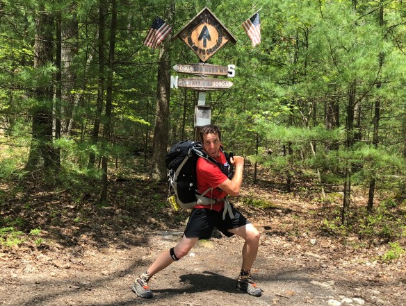
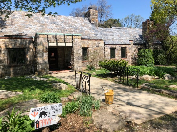
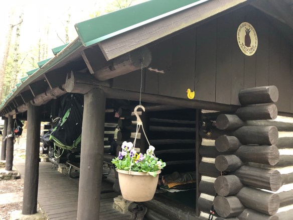
Day 72. The extra mileage I hoped to put in yesterday was made up today. I got up early and hit the trail before 7:30, allowing me to leisurely make my way up the 25 miles to my destination tonight with plenty of rest breaks in-between and daylight to spare. And what a place it is! There is something special going on with the Potomac Appalachian Trail Club (PATC) that maintains the couple hundred miles of trial around Harpers Ferry. This is another great shelter they support with amenities galore. In fact, this one even has a bit of B&B style appeal that could even make my mother consider a backpacking overnight. :-).

The Quarry Gap Shelter is maintained by Jim “Innkeeper” Stauch, who has clearly put work in to this haven. It’s a peaceful oasis in the rhododendron forest you hike through on your way uphill. It’s technically 2 small shelters that hold 3 people a piece, but are connected by a large overhang covering and picnic table. Beyond that, there are elevated tent pads, a separate covered picnic area, benches, games, a bear box and flowery accoutrements everywhere you look. It would be very easy to grow roots here and enjoy this tranquility permanently if I wasn’t on a mission. I mean, look at the cute detailed additions below!

I am not alone here, but it’s not too crowded either. About 7 people are spread around different parts of the shelter area (a dad and his 6 year old daughter walked up as I wrote that, bringing the total to 9). As I sit here writing this, there is a hiker playing guitar near the shelter, two more swinging on the bench, and 2 more wandering the paths that curiously stretch out like fingers from the center. I’m telling you, it’s a special place. Once again, I’ll be adding this to the king growing list of places to come back to in the future.

It was worth the long day to get here, although (of course) the last 2 miles are straight up. This morning started with calm blue skies and it didn’t change all day. Early on, I got a nice view at High Rock (though unfortunately the vista’s rocks were covered in spray paint graffiti … a sad sight to see). That rock cliff has a road that goes right to it from Pen Mar Park below, so it must be a common teenager hangout.

Down at Pen Mar Park, a couple miles further along, a beautiful picnic area with the same incredible western view greets you. Normally, this is a great place to stop, as it has a concession stand and bathrooms for the public … but they were closed, even though the guidebook said it should be open. Harrumph.

Just after the park, you cross some railroad tracks and come to a signpost identifying the MD-PA state line – and with it, the Mason Dixon Line. Continuing the trend of awesome history separating this part of the trail from the rest, I sat at the border and pondered it’s significance while I enjoyed a snack. Along with this line that divided our county, I saw signs for Antietam, Gettysburg and other relics of our nation’s soiled past as I walked today. It is both humbling and empowering to hike through places where so many American soldiers killed each other to secure our nation’s future. You read about it, you watch movies about it, you imagine it … but you can’t truly understand it. Standing right at the spot where blood was spilled is a different feeling altogether. Truly powerful stuff for the mind of a Minnesotan to ponder, whose state barely existed in the same world.

I passed a few other shelters and campgrounds today on my trek northward, all showing off the good graces of the PATC some more. I saw a few day hikers as I went as well (startling most of them as I turned the corner singing to myself). But i didn’t see any other thruhikers until the end. Even with my long day, filled with breaks and pauses, I still was able to call it quits before 5pm. I almost considered going further, but this shelter was too beautiful to pass up for the night. It’s one issue is lack of trees to hang, so I’m sleeping in one of the shelters tonight. But, it’s so clean and pretty, I’m ok with that.

Hello Neiman (Sharkbait)!

  • Start Mile: 1060.8
  • Start Time: 07:30
  • End Mile: 1086.2
  • End Time: 16:15
  • Miles Hiked: 25.4
  • Miles to Go: 1104.7
  • Lodging: Quarry Gap Shelters

Day 71: Raven Rock Shelter

Day 71. I had hoped to put in near 25 miles, but for no good reason it was a sluggish day for me. I started late, I hiked slow, and the trail just seemed to go on and on without end. There were some neat sights early on, but the afternoon was met with on and off rain that I never seemed to get comfortable with.

A few miles in, I was able to take a short side trail and visit the original Washington Monument (above). This stone tower was built in 1827 (60 years before it’s more famous brother), and provided snippets of our 1st President’s history on signposts leading up. It was an exceptional landmark to see, and upon climbing up to the top … gave a breathtaking view of Maryland. Unfortunately, it also gave a clear view of the fast approaching storm clouds, so I quickly downed my Snickers snack and moved on.

I used to live in DC, so I am familiar with the high humidity and daily 15 minute rainstorm that is common during summer afternoons. Today was a bit like that, but with the rain returning for a quick dump every few hours. The good news is that I was lucky in that the foreshadowed thunderstorm was heard in the distance, but never directly above me. That was a nice surprise at least.

Like yesterday, I saw plenty of hikers today. I realize now that this is because I am in the middle of AT flip-flop thruhiker season. For those unfamiliar, a flip-flopper is someone who starts in the middle of the Appalachian Trail and hikes North to Maine, then flies down to Georgia and hikes back to the middle where they started. There are many variations on it, but that is the general idea. The most common place to start/end is Harpers Ferry, and the most common time is May.

So there is a new influx of hikers on the trail with me now. I don’t mind this at all, as it’s nice to have the company of others again. Today’s shelter, for example, has 15-20 hikers here with me tonight. I won’t see most of these hikers again, as they are starting slower than my current pace, but there will undoubtedly be new hikers to meet each day for a couple weeks.

It’s not as common as the standard Northbound hike I am doing, but it’s becoming more popular with the help of the Appalachian Trail Conservancy (ATC). They have been promoting this strategy for years, as it helps their cause to lessen the human impact of overcrowding the trail, and allows their HQ location in Harpers Ferry to help educate and support you better from the start. Last year, approximately 4000 people started Nobo from Georgia, whereas 400 started a flip-flop in Harpers Ferry. In case you are curious, the completion rates are about the same, 20% no matter which direction or style you try it. Statistics junkies can learn more halfway down the page here.

I chatted for a bit with the other hikers over dinner, and laughed to myself on how green the flip-flippers are right now. I was 100% the same way when I started of course, talking proudly about everything I thought I knew but had yet to experience. And although I felt well educated (and they sound it too), nothing compares to actually being out here. I’m humbled in that realization as I write this Day 71 post … I was the most prepared person I knew, and I got a lot wrong. When it comes to thruhiking, nothing can prepare you except a thruhike. You simply don’t know until you know. And now you know. 🙂

Hello Neiman (Sharkbait)!

  • Start Mile: 1040.2
  • Start Time: 08:20
  • End Mile: 1060.8
  • End Time: 16:15
  • Miles Hiked: 20.6
  • Miles to Go: 1130.1
  • Lodging: Raven Rock Shelter

Day 70: Rocky Run Shelter

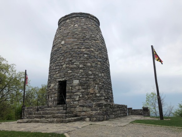
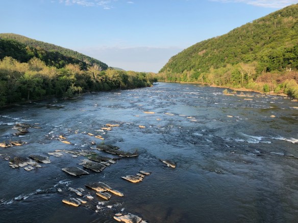
Day 70. I made my way back to Harpers Ferry at 11am and officially checked in the ATC for my photo. The ATC is the organization that formally tracks the member numbers each year, even though its collected voluntarily. They are the unofficial agency overseeing the trail which provides support, education, and resources to the AT community of hikers. This building acts as their headquarters and trail museum, with tons of great resources for current and aspiring hikers. I respect what they do for this trail, so I gave them an appropriate pose for my photo.

When I started in Amicalola Falls, I registered with the ATC staff there, receiving my orange 2018 badge and hiker number. I was Northbound hiker #436 when I started March 1st, but when I checked in with them today, I was #137. And that’s after waiting two days to get back here, since it wasn’t open when I rolled in on May 7th ( I would have been #130). Retention rates say 25% of thruhikers are still hiking at this point, and that number differential is right in line … though it is also influenced by my speed of late.

I spent an hour hiking from the ATC to old town Harpers Ferry and touring the old historic city. It truly is an incredible place to visit, as it is overflowing with Civil War landmarks and battle stories. The AT and hiker community is a smaller subset of the culture in town, but it was still prominent. Many tourists stopped to ask me questions and chat about my trip. There is also a very small outfitter with good supplies and gear to peruse. Also, small restaurants galore. Spending a day here would be a fantastic time in the future. Fortunately, I’m moving to Virginia in a few months so I’m sure to come back.

The first few miles of the hike today were along the Potomac River on a wonderfully paved road. You cross the river immediately upon departing Harpers Ferry, marking entry to Maryland and my 6th state. Many hikers, bikers, and walkers strolled the path and we all enjoyed a beautiful sunny afternoon together. The trail was covered in bright green leaves and looked breathtaking. I snapped a photo (above), which is darn near frame-worthy if I do say so myself. In addition, giant turtles line the stagnant pond that paralleled the river walk. I tried to get a close enough picture to see them too, but it isn’t great. There are at least 6 sunbathing on that log below.

After that, I briefly hiked through Gathland State Park, with it’s monuments and civil war era building relics. It’s small, but provided a short and nice break before climbing up 1000 feet for the next 2 miles. It was great hiking though – the “Green Tunnel” nickname of the Appalachian Trail finally started to make sense as I hiked under a canopy of lush oak and other large trees. It shaded the sun and made for a pleasant afternoon.

I passed the first couple shelters and eventually stopped at Rocky Run Shelter at half past five. This shelter is actually 2, as the original one has been superseded by a brand new replacement closer to the trail. It’s isn’t anything special, but it’s shiny, new, clean, and comfortable. I had dinner and setup camp for an early turn-in.

I was up too late last night contemplating, organizing, and reviewing my gear for this 2nd half hike, so I’m exhausted. But it appears to be worth it, as the changes already are paying dividends (e.g. shoes, poles, filter/flask). Allenberry is only 82 miles away and I’d like to get there by Sunday for my next milestone, so the next week looks pretty nice. Besides the thunderstorms expected tomorrow. Woot!

Hello Neiman (Sharkbait)!

  • Start Mile: 1024.8
  • Start Time: 12:00
  • End Mile: 1040.2
  • End Time: 17:30
  • Miles Hiked: 15.4
  • Miles to Go: 1150.7
  • Lodging: Rocky Run Shelter

Day 69: Harpers Ferry Zero Day

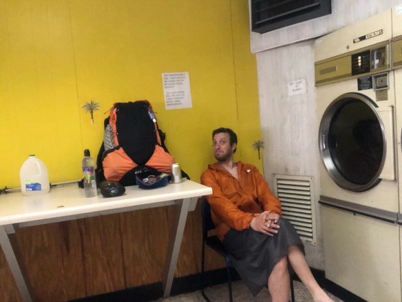
Day 69. Now that I have reached the (unofficial) halfway point to my Appalachian Trail thruhike, I used today to conduct a much needed and full evaluation of my backpacking gear thus far. Even though I am in Harpers Ferry, mileage wise, I spent my day off with family in Potomac, MD instead. It was a great rest day that included a massage, a trip to REI, a resupply, and a fun night babysitting my nephews. These days are precious to a healthy physical and mental experience on the AT. If nothing more, to be a goal you strive towards and then reward yourself for achieving.  But, let’s get back to the matter at hand. Gear, glorious gear.

I spent months years planning the gear I brought with me to Springer Mountain. So after 1000 miles on this trail, how did it all fair? Some worked out better than expected, some worse. Some things were replaced early on, others have lasted the test of time. I went through everything on my original Gear List, and others that were added later. If it isn’t important, I didn’t mention it below … but almost everything is important so it’s a long list. Apologies to those who don’t care, you can come back tomorrow. For everyone else, here’s a detailed breakdown of how my gear handled 1000 miles, and what is changing changing for the 2nd half of this adventure beginning tomorrow.

  • Backpack: As I mentioned a few times over the past few weeks, I failed to realize how much weight I would lose on this trip, and how it would effect the fit of my backpack. My Osprey Talon 44 has a hip-belt for a minimum men’s waist of 32″.  After losing 20 points in 2 months, I am now at a 30 or 31 inch waist. You cannot adjust or replace the hip-belt for a smaller size, so I have been forced to wear much of my pack weight on my shoulders for weeks. I considered replacing it with the Osprey Levity (their new ultralight series), but don’t want it to be obsolete a year from now when I gain that weight back. Also, I never saw a single one on the trail and wasn’t impressed in person. The two most popular UL alternatives on the trail are the ZPacks Arc Blast/Haul and the ULA Circuit. Neither are available at REI or local retailers in DC, so I ordered both to test which I like better. They are very similar, and both have their perks. Unfortunately, neither arrived in time, so I’m stuck with the Osprey until next weekend when they hopefully arrive and my sister can bring them to me. My gut says ZPack, because of the air ventilation in back, but we shall see.
  • Hammock & Tarp: Working great! I am proud to admit that I get a lot of compliments for my hammock setup. The Dutch Chameleon Hammock is solid, and the UGQ Winter Dream Tarp is heavily envied by other hammock hangers. The storm doors and large size for such a small weight are perfect for nights of heavy rain or wind. At least two other hikers have bought one after eying mine.
  • Hammock Quilts: No issues, complaints, nor changes. I was going to swap these 20 degree Enlightened Equipment quilts out for smaller summer ones, but I decided there is no reason to. They are great and although may be too hot at times, that can be mitigated easily. And I’ve never been too cold. There were some close nights in the Smokies, but it was manageable with a good sleeping pad and long underwear.
  • Sleeping Pad: This is old news by now, but my Thermarest Z-Lite Sol was unbearable as an emergency shelter pad. It was not nearly enough for a side sleeper like me, so I never slept more than an hour a night when trying to use it. I swapped it out in Gatlinburg for a Thermarest EvoLite, but then again swapped that out for the smaller, thicker, and lighter Nemo Astro Lite in Damascus. It was 40% off and too good a deal to pass up for those upgrades. This one is so nice, I almost don’t mind sleeping in shelters anymore … almost.
  • Shoes: If you’ve been following me this long, you know my frustration with the rocky trail terrain on my feet. I started with Salomon X-mIssion 3s, then bought Salomon XA Pro 3Ds for my 2nd pair because of the thicker sole andtoe box. Both have worked well, but neither protected my feet as much as I’d like on those rocks. Those were pretty good, but for my 3rd pair, I’m thickening the sole even more and going with Oboz Sawtooths (the boot I initially planned to start with). I already know they fit me well, and they should protect my feet more as a boot than trail-runners do. I’ll best these rocks yet!
  • Hiking Poles: I thought I didn’t need them, and I was dead wrong. After 4 days, I purchased LEKI Cressida Poles at Mountain Crossings. They have saved my life from rocks and rivers more times than I can count. Don’t be dumb like me, bring poles. And these ones are great, they are lightweight and have a really comfortable and lightweight cork handle. However, the metal tips broke (a day apart) about 2 weeks ago, and the 3 inches of plastic on the rest of the tip wore down to 1 inch in that time. LEKI doesn’t cover this in their warranty, but REI sells replacement tips for $20. I picked up a pair and swapped them out today.
  • Clothes: Short answer for a big category … Things that exceeded my expectations and should be considered by every hiker: Merino Wool T-Shirtand Dexshell Waterproof Socks. Things that are good and unchanged don’t need to be mentioned, those that failed or I’m done with are further itemized below.
  • Hiking Pants: Great early on, but unbearable as I lost weight. They caused my boxers to ride up and chafe more than normal, and the belt was more and more irritating as the inches came off. Now that it’s warmer, I am sending these home and replacing them with Nike Dri-Fit pants. They are extremely light weight and will serve my needs if its ever too cold for my Dri-Fit shorts. The shorts will be my hiking attire, but the pants will serve multi-purpose at night or on cold hiking days.
  • Underwear: Absolutely loved the Merino Wool Boxer Briefs. When combined with the T-Shirt, I swear I never had the “dirty hiker” smell. The material is very comfortable and completely odorless, keeping your stink very bearable. However, the boxers wore out after 4 weeks. Because of my hiking pants (see above), they rode up on me constantly and the thin material fell apart. I had to send them back to Smartwool to be replaced (warranty). Using my shorts and new pants, this hopefully shouldn’t be an issue again … when I get my replacement pair in 4-6 weeks. 😦
  • Fleece / Puffy: Both my Patagonia R1 Fleece Hoody and my Mountain Hardware Ghost Whisperer Puffy are excellent. The fleece is my best piece of gear, by far. Now that it’s warm, I don’t need both. So I am sending the puffy home for now and will pick it up again before the Whites.
  • Long Underwear: Worked great, but leaving home now for the summer.  I wore the pants at night a lot, but almost never wore the top. I wore my R1 Fleece every night at bed instead, which was more than enough warmth (excluding some of those early bitter cold snowy nights). Better to be safe than sorry on this one, so the thermals are coming back before the Whites too.
  • Winter Hat and Gloves: Needed them almost every day or night until Damascus, as this year was unseasonably cold. But stopped needing them mid-way through Virginia, so sent them home today. Will be the 3rd item I pick up again before the Whites.
  • Rain Jacket: The OR Helium II rain jacket is very popular out here, and mine worked great. But without pit zips, i constantly sweat on the inside and was just as wet. I don’t know if a jacket with pit zips would make enough difference, or a poncho for that matter, but it worked well enough for me this far. You’ll get wet, no way around that, so whatever makes you comfortably wet is the solution. This was and still is mine.
  • Rain Skirt: The skirt, on the other hand, was a knockout winner. I could never wear rain pants and handle sweat on my bottom half the same way. The EE Rain Wrap is another A+ gear item that others were envious of, and I love having out here. And I don’t care if it looks like I’m wearing a garbage bag, Mirra!
  • Buff: Everyone loves the buff these days, and I’m fully on board. I sent my extra bandana home after a couple weeks and use this almost every day. I hike in it and I sleep it in (great sleep mask). It’s also a nice lightweight hat, towel, etc.
  • Socks; Three pairs is the right amount for me. One pair of waterproof socks, one pair of Darn Tough wool socks, and one pair of Injinji wool Toe Socks. The toe socks were added after a pair of Smartwools quickly fell apart. They are important for me at night also, as my camp shoes are now flip-flops (see below). But they also were very helpful during the 4 days of straight rain when I started getting blisters.
  • Camp Shoes: I was ready to throw my Crocs away after 2 days but had to wait a week to finally find a pair of flip-flops at the Hiawassee Dollar General to replace them. Crocs are good camp shoes, but too bulky and heavy. I have only taken my boots off once to cross water, and I just walked across barefoot. When I hit Maine, I’ll need river shoes, but I’ll deal with that when the time comes. I did need to replace my original flip-flops in Waynesboro, as they started to wear thin … but at $1 a pair, I’m ok with that.
  • Food Bag: The Lopsak Opsak odorless bag was a great addition, but it is not very well made. Both this one and the tiny wallet bag I bought in Hot Springs quickly broke at the top where the seal closes. Its now very hard to open and close without leaving a hole (eliminating it’s purpose). I still use it, but would recommend any one else wanting to odor-proof their food to have extras ready at home for replacement.
  • Water Purification: I covered this in an earlier post as well, but my Aqua Mira phase is over. The combination of the solution eating a hole in my backpack pocket, bleaching my t-shirt, and being far too long to wait for on a hot day, did it in. Good for a short trip maybe, but not a thru-hike. I’m loving my Katadyn BeFree filter now, but the 0.6L flask I bought was too small. Today I bought a 2L Hydropack Seeker flask for it instead, which allows me to fill up once, and use it to fill both my smartwater bottles.
  • Battery Charger: If anyone tries to convince you that you need more than a 10,000 mAh charger, they are wrong. I have only come close to running out of juice on my Anker Powercore once, and didn’t even then.
  • Bag Cover / Liner: I thought my Sea to Summit Pack Cover would be enough, but it wasn’t. The rain seeped through early on and I added a cheap trash compactor bag on the inside to keep everything waterproof. It is starting to fall apart though, so I bought a 35L Ultrasil Dry-Bag today instead. Now everything goes in that, and that goes in the backpack. When I get my new backpack, which is considered “waterproof”, I’ll consider sending the Pack Cover home.
  • Headlamp: My cheap amazon eGear Headlamp is great for everything except night hiking. It has a much dimmer light than that of others, and is not enough for a true dark hike. But that’s ok, I only did it once and did not enjoy it, so won’t again. Their is a benefit to the dim light though, as it is easily useable in the shelter without annoying others. The heavier, more expensive headlamps have a red light for this reason … mine doesn’t need it.
  • Ear Plugs: I use them almost every night. I have avoided hearing many loud shelter farts thanks to these wonderful tiny ear canal sponges.
  • Mosquito Head Net: Haven’t used it once yet, but the bugs are coming. It’s 1 oz will come in handy very soon.
  • iPhone / Camera / Kindle: My used iPhone SE did not survive through the Smokies. My case was not waterproof, which likely caused the issue, but the screen was simply too small too. It was annoying (and difficult) to have to get a new phone in Gatlinburg, but the larger iPhone 8 is significantly better. Because of the larger screen, I was able to send home my Kindle eReader as well, ridding me of those unnecessary 7 ounces. Also, this time I didn’t mess around and bought the expensive Lifeproof Fre Waterproof Case.
  • Stove: The only item from my cooking gear that I changed was the stove. I originally brought a homemade alcohol stove and the BRS Ultralight canister stove as a backup. The alcohol stove failed me for 2 reasons and eventually was tossed. One, the alcohol would sometimes have trouble lighting in sub-freezing temperatures (which occurred too often). And two, the gas canisters easily last me 2 weeks before needing to be replaced. I had to replace alcohol every 3-4 days for the same weight of a canister. They sell them everywhere, so it has never been an issue.
  • Spork: Technically I didn’t change this … I just had to keep replacing it. My original plastic spork was lost, my replacement broke, my next replacement broke, and my 4th has finally lasted. A smarter Sharkbait would have bought a titanium spork with a hole and clipped it to my backpack, but I am not he.
  • Health Kit: Because I was chastised for it during my planning, I will give an update to this. I used 3 of the 6 band-aids and replenished them a few days later. I also have used just one of my pre-packaged mini-rolls of Leukotape (3 feet), but I’m glad I have more coming in each resupply box anyways. This is hard to replace on the trail and could be used up quickly. Also replaced some molefoam after the blister week. That’s it.
  • Repair Kit: I’ve used almost none of this. I replaced the rubber bands with hair binders that won’t break as easily, I used a few scraps of duct tape on one of my replacement sporks, and a couple extra carabiners for my hammock tarp. Everything else is unused.
  • Med Kit: I feel I don’t need Ibuprofen much at all. It may help if I take it, but I find that any pain subsides pretty quickly once I start walking. I do use my Ibuprofen PM whenever I sleep in the shelter though. I really struggled to sleep well in them, and the sleep-aid helps. Other than that, I thankfully haven’t needed much else (including Zyrtec).
  • Bug Spray: Haven’t used once, but like mentioned above … they’re a-coming.
  • Toothbrush: I replaced mine a couple times out here, just to be safe and clean.
  • Anti-Chafe Balm: I replaced my original Body Glide stick after a few weeks, but haven’t used it lately. I think your thighs gets acclimated to the rubbing after a while, and then it doesn’t chafe any more … at least, that’s been my experience.
  • Pillow: Waste of $40, sent it home after a couple weeks. The Exped AirPillow UL was slippery and constantly fell out from under me. Plus, I was much happier using my Puffy. Even on the coldest of nights, I never slept with my puffy on as it would block the body heat from my torso from reaching the rest of my body in my quilt.
  • Foot Massager: My pickle ball was a HUGE success (with me and others), and was part of my required nightly stretching routine for weeks. But once my trail legs came in at Hot Springs, I no longer needed it. I sent it home in Damascus.
  • Frisbee: I decided not to bring one, then bought one in Hot Springs. After not using it for 2 weeks, I sent that one home in Damascus. There was simply never a chance or people to toss with. (Any friends joining me in Maine would be wise to bring one for us though, hint hint).
  • Corncob Pipe: Alas, I’ve used this only 2 or 3 times. Its funny, because I enjoy it on other camping trips and thought I’d love having it out here. But I am so tired at night that I pass out almost immediately after dinner. There were a couple good opportunities with campfires early on to relax with my pipe, but nothing in weeks. I’m keeping it (for now) because I’m stubborn, but this is probably dead weight.

And that’s everything worth noting! Sorry it’s so long, but if you didn’t care for detailed gear reviews on a thru-hike, you probably aren’t reading this blog … and you definitely didn’t get to the end of this post. As for me, I am now (almost) all fixed up with my gear and ready to hit the trail again. My backpacks will hopefully arrive by Saturday, so I can compare the 2 options and swap out the Osprey when my family comes for one last visit in Allenberry, PA. As for my mental fortitude, I am good to go. I am eager for the next 1166.1 miles and to conquer the rest of the beast that is the Appalachian Trail. Still loving it, still hiking it!

Hello Neiman (Sharkbait)!

  • Start Mile: 1024.8
  • Start Time: 00:00
  • End Mile: 1024.8
  • End Time: 00:00
  • Miles Hiked: 0.0
  • Miles to Go: 1166.1
  • Lodging: Family (Potomac, MD)

Day 68: Harpers Ferry, WV

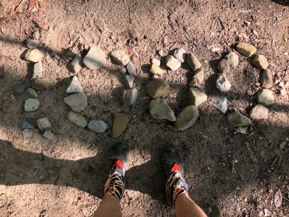
Day 68. After 12.5 hours of walking, I finally marched through historic Harpers Ferry, WV at 7:15 pm, thus completing my 30.4 mile day on the Appalachian Trail and reaching the (unofficial) halfway point. My feet are completely beaten and my body thoroughly exhausted, but my spirits are flying high and my rest day is reached. Hello Harpers Ferry!

If I would have broken today into 2 hiking days, it would have been significantly easier, but the second I woke up, I knew I was going all the way. I was awake at 6am and on the trail before 7, which has to be a new record for me. As I was packing up, I learned Spice was one of the other 9 inhabitants of the shelter last night, so we chatted over breakfast and I told her of my crazy plan. She wished me luck, but assured me that she would not follow my lead.

The weather was supposed to be gorgeous, with sunny skies and mid-70s temps throughout the day, so I hit the road. The day was split into 3 sections of 10 miles, each with their own challenges.

The first one up was The Roller Coaster, which didn’t really live up to the hype. Perhaps it’s a big deal to day hikers, but going up and down small hills one mile at a time is nothing to me these days. In fact, it was easier because of how short each climb was. Some were steep, but really not too bad. After the first 2 climbs, I found the marker signifying 1000 miles, and a large group of hikers all gathered around. It was 6 of the hikers from the shelter last night who I learned are a tramily that has hiked together since Georgia. They all had the same ULA Cirquit backpack, and all looked to be 23 year old college grads. They were gathered here for a photo op and snack, so I joined for both.

Shortly after that, a sign welcomed me to visit a hostel/learning center for a break once I finish The Roller Coaster, though technically there are still 4 miles more after that point (according to my guidebook). I thought it would be a good rest stop for a snack, as it signifies 1/3 of today’s hike would be done. Unfortunately, the Bears Den Hostel was closed when I arrived at 10am, so it was only a very brief stop. I had my snack outside at the picnic table and marveled at the beautiful stone building. Its a rather impressive site that I expect is a treat to visit on other occasions.

Then I trudged on. The next 10 mile section was a frustrating meander through woods and small hills. Normally this would have been great hiking but for 2 problems. There were almost no streams to refill water, and the trail was once again my familiar rocky enemy. I continue to be astonished at what the communities that maintain this trail seem to think is acceptable. I would never recommend children or elderly hikers to attempt these sections, as they are dangerous and painful for miles on end. Hiking, as most people experience it at a national or state park, provides certain luxuries of trail conditions that I’ll never again take for granted. As I carefully made my way over and around the boulder infested trail, I tripped, slipped, or clipped a foot more times than I can count … and cursed a few times more than that.

The final section was a bit of a death march. Not for any fault of the trail, it was actually pretty good. Flat, less rocky than before, and water galore. This was the section where Virginia and West Virginia criss-cross leading to the Shenandoah River and Harpers Ferry. Unfortunately, I had trouble enjoying it as I was now exhausted and my feet’s rawness made every step feel like razor blades. Ok, that’s an exaggeration, but not too far off.

However, when I finally saw my destination, it was all worth it! The Shenandoah River came into view and signified the end of my 30 mile triumph. And what a view it was! I crossed the river into Harpers Ferry and made the final half mile climb to the city center and the home of the Appalachian Trail Conservancy!

One down side. The ATC, and really all of Harpers Ferry closes at 5pm. It was almost like walking through a ghost town when I arrived after 7 o’clock. I couldn’t even find a restaurant open for dinner! I will come back to the ATC in a couple days to officially register my half-way point and check out the town. But for now, I walked down to the train station and waited for my family to pick me up. Then we headed back to Potomac for my highly anticipated day off. Tomorrow will be a big day of recovery, shopping, eating, and gear reorganizing.

Hello Neiman (Sharkbait!)

  • Start Mile: 994.4
  • Start Time: 06:50
  • End Mile: 1024.8
  • End Time: 19:30
  • Miles Hiked: 30.4
  • Miles to Go: 1166.1
  • Lodging: Family (Potomac, MD)